![](/images/other/stat-length.png)
![Excursión Esquí de fondo La Léchère - Les marmottes noires - Photo](https://media.geolcdn.com/t/1900/400/b231a722-c719-4ca9-8520-60ac6ec172da.jpg&format=pjpeg&maxdim=2)
Les marmottes noires
nadd73
Usuario GUIDE
![Longitud](/images/other/stat-length.png)
Longitud
13,2 km
![Altitud máxima](https://static1.geolcdn.com/siteimages/upload/files/1508320355ic_sort_altitude_max_24dp.png)
Altitud máxima
2312 m
![Desnivel positivo](https://static1.geolcdn.com/siteimages/upload/files/1508320355ic_sort_den_pos_24dp.png)
Desnivel positivo
1086 m
![Km-Effort](/images/other/stat-length.png)
Km-Effort
28 km
![Altitud mínima](https://static1.geolcdn.com/siteimages/upload/files/1508320355ic_sort_altitude_min_24dp.png)
Altitud mínima
1290 m
![Desnivel negativo](https://static1.geolcdn.com/siteimages/upload/files/1508320355ic_sort_den_neg_24dp.png)
Desnivel negativo
1110 m
![Boucle](https://static1.geolcdn.com/siteimages/upload/files/16400158638029165_repeat_loop_refresh_sync_direction_icon.png)
Boucle
Sí
Fecha de creación :
2023-12-16 08:41:17.366
Última modificación :
2023-12-17 06:25:45.408
![Esquí de fondo](https://static1.geolcdn.com/sitytour/trail-icons/503.png)
4h50
Dificultad : Medio
![Escanee este código QR para abrir la excursión en la aplicación SityTrail](https://capi.geolives.com/qq0zvz2zws4bq2lad0pu/sitytour/trails/3895163/qr.png?size=200)
Aplicación GPS de excursión GRATIS
A propósito
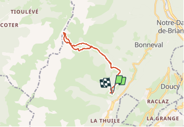
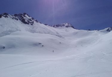
Ruta Esquí de fondo de 13,2 km a descubrir en Auvergne-Rhône-Alpes, Saboya, La Léchère. Esta ruta ha sido propuesta por nadd73.
Descripción
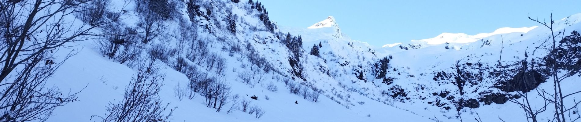
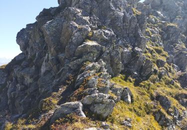
il est préférable de passer par l'itinéraire de descente car très galère par la montée que j'ai faite.
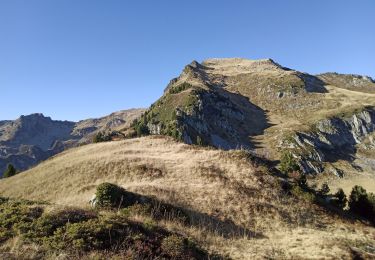
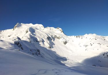
vue toujours aussi magnifique !
Localización
País:
France
Región :
Auvergne-Rhône-Alpes
Departamento/provincia :
Saboya
Municipio :
La Léchère
Localidad:
Bonneval
Salida:(Dec)
Salida:(UTM)
299335 ; 5041719 (32T) N.
Comentarios
Excursiones cerca
![Excursión Senderismo Les Belleville - Tour de Creve Tete - Photo](https://media.geolcdn.com/t/375/260/775f7fbd-61fe-4dac-aa88-5ad251aeb72f.jpg&format=jpg&maxdim=2)
![Senderismo Senderismo](https://static1.geolcdn.com/sitytour/trail-icons/101.png)
Tour de Creve Tete
Senderismo
Medio
(1)
Les Belleville,
Auvergne-Rhône-Alpes,
Saboya,
France
![](/images/other/stat-length.png)
18,1 km | 34 km-effort
4h 49min
![](https://static1.geolcdn.com/siteimages/upload/files/16400158638029165_repeat_loop_refresh_sync_direction_icon.png)
Sí
![Excursión Esquí de fondo La Léchère - grand pic - Photo](https://media.geolcdn.com/t/375/260/9cfac439-c6a9-45dc-854a-66e0fdb870fb.jpg&format=jpg&maxdim=2)
![Esquí de fondo Esquí de fondo](https://static1.geolcdn.com/sitytour/trail-icons/503.png)
grand pic
Esquí de fondo
Muy fácil
(1)
La Léchère,
Auvergne-Rhône-Alpes,
Saboya,
France
![](/images/other/stat-length.png)
13,8 km | 33 km-effort
3h 34min
![](https://static1.geolcdn.com/siteimages/upload/files/16400158638029165_repeat_loop_refresh_sync_direction_icon.png)
Sí
![Excursión Senderismo La Léchère - pte de Glais rouge, des Arangles et Roche brisée - Photo](https://media.geolcdn.com/t/375/260/1baaaa90-37a8-4237-b92e-53be672474e7.jpg&format=jpg&maxdim=2)
![Senderismo Senderismo](https://static1.geolcdn.com/sitytour/trail-icons/101.png)
pte de Glais rouge, des Arangles et Roche brisée
Senderismo
Difícil
La Léchère,
Auvergne-Rhône-Alpes,
Saboya,
France
![](/images/other/stat-length.png)
9,3 km | 21 km-effort
4h 20min
![](https://static1.geolcdn.com/siteimages/upload/files/16400158638029165_repeat_loop_refresh_sync_direction_icon.png)
Sí
![Excursión Esquí de fondo La Léchère - Aiguille de la Balme - Photo](https://media.geolcdn.com/t/375/260/a3d2e41a-1caa-427e-9d80-b714bd5aac52.jpg&format=jpg&maxdim=2)
![Esquí de fondo Esquí de fondo](https://static1.geolcdn.com/sitytour/trail-icons/503.png)
Aiguille de la Balme
Esquí de fondo
Medio
La Léchère,
Auvergne-Rhône-Alpes,
Saboya,
France
![](/images/other/stat-length.png)
11,6 km | 28 km-effort
4h 19min
![](https://static1.geolcdn.com/siteimages/upload/files/16400158638029165_repeat_loop_refresh_sync_direction_icon.png)
Sí
![Excursión Esquí de fondo La Léchère - tricotage vers Les Teurs. - Photo](https://media.geolcdn.com/t/375/260/00642df7-11bb-44cc-a75b-471b0d819f21.jpg&format=jpg&maxdim=2)
![Esquí de fondo Esquí de fondo](https://static1.geolcdn.com/sitytour/trail-icons/503.png)
tricotage vers Les Teurs.
Esquí de fondo
Fácil
La Léchère,
Auvergne-Rhône-Alpes,
Saboya,
France
![](/images/other/stat-length.png)
13,1 km | 28 km-effort
4h 2min
![](https://static1.geolcdn.com/siteimages/upload/files/16400158638029165_repeat_loop_refresh_sync_direction_icon.png)
Sí
![Excursión Esquí de fondo La Léchère - le. chalet de Colomban - Photo](https://media.geolcdn.com/t/375/260/8594f6fb-22c5-4295-85ac-3463a33ec2ed.jpg&format=jpg&maxdim=2)
![Esquí de fondo Esquí de fondo](https://static1.geolcdn.com/sitytour/trail-icons/503.png)
le. chalet de Colomban
Esquí de fondo
Fácil
La Léchère,
Auvergne-Rhône-Alpes,
Saboya,
France
![](/images/other/stat-length.png)
10,1 km | 22 km-effort
2h 0min
![](https://static1.geolcdn.com/siteimages/upload/files/16400158638029165_repeat_loop_refresh_sync_direction_icon.png)
No
![Excursión Senderismo La Léchère - les marmottes noires et Bellacha - Photo](https://media.geolcdn.com/t/375/260/2e4efe3f-cf03-4e44-8f86-163d48b8b315.jpg&format=jpg&maxdim=2)
![Senderismo Senderismo](https://static1.geolcdn.com/sitytour/trail-icons/101.png)
les marmottes noires et Bellacha
Senderismo
Medio
La Léchère,
Auvergne-Rhône-Alpes,
Saboya,
France
![](/images/other/stat-length.png)
12,2 km | 27 km-effort
5h 25min
![](https://static1.geolcdn.com/siteimages/upload/files/16400158638029165_repeat_loop_refresh_sync_direction_icon.png)
Sí
![Excursión Senderismo La Léchère - lac de Clartan et grande muraille - Photo](https://media.geolcdn.com/t/375/260/4b4bb2ac-ceed-47da-944d-e4142550d609.jpg&format=jpg&maxdim=2)
![Senderismo Senderismo](https://static1.geolcdn.com/sitytour/trail-icons/101.png)
lac de Clartan et grande muraille
Senderismo
Difícil
La Léchère,
Auvergne-Rhône-Alpes,
Saboya,
France
![](/images/other/stat-length.png)
4,6 km | 9,9 km-effort
3h 7min
![](https://static1.geolcdn.com/siteimages/upload/files/16400158638029165_repeat_loop_refresh_sync_direction_icon.png)
Sí
![Excursión Esquí de fondo Montsapey - Combe bronsin collu au Nord 2400 - Photo](https://media.geolcdn.com/t/375/260/075f145a-4ea4-41d5-a1b1-7236cce549f1.jpg&format=jpg&maxdim=2)
![Esquí de fondo Esquí de fondo](https://static1.geolcdn.com/sitytour/trail-icons/503.png)
Combe bronsin collu au Nord 2400
Esquí de fondo
Fácil
Montsapey,
Auvergne-Rhône-Alpes,
Saboya,
France
![](/images/other/stat-length.png)
10 km | 25 km-effort
4h 19min
![](https://static1.geolcdn.com/siteimages/upload/files/16400158638029165_repeat_loop_refresh_sync_direction_icon.png)
No